As the name suggests this is a high walk in the mountains of the Sierra de Grazalema. But, the easy access by road gains the altitude for you and then the walk is a fairly short circular one that goes around the peak rather than climbing to the top of it.

This walk offers spectacular views and gives an overview of the whole area with 360 degree views from the peak itself. The peak of Coros is 1,328m above sea level and the car park 1,157m. The walk takes about 1.5 at a leisurely pace to complete the 2.7km and may give amazing sightings of Griffon Vultures, from above and below. The terrain is rugged limestone rock with rough grasses, stunted oak trees and sparse Mediterranean scrub.
How to get to the Puerto de la Palomas.
Park in the large area at “Puerto de Las Palomas” which is on the CA9104 road from Grazalema to Zahara de la Sierra.
Place your back to the view point “Mirador”/road and beyond the car park on the left hand side the trail begins at a slight incline passing through a rustic fence gate. (Not the big green gate on the right!)
Sensible shoes please?
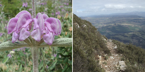
The path is narrow and bordered by rock and amongst the rocks are a myriad of plants that have adapted to these altitudes and exposure to the elements such as Woolly lavender (Lavandula lanata), Blue Aphyllanthes (Aphyllanthes monspeliensis), Silver-leaved bugloss (Echium albicans) and White Flax (Linum suffruticosum).The path continues to climb steadily, crossing loose stones that form part of a scree slope. Along here there are several small examples of Spanish Fir trees which are endemic to this area of south western Spain and a relict of the Tertiary period. (There is an area of dense forest of this species, on the northern slopes of Sierra del Pinar).
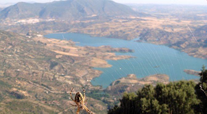
Incredible views
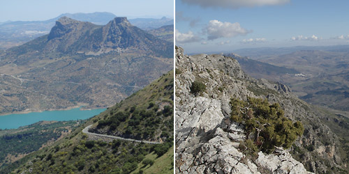
The views take in the reservoir and hilltop tower of Zahara de la Sierra, just beyond this is the village of Algodonales with a long hill behind called Sierra de Líjar that is well known for hangliding.
The reservoir forms the northern border of the parkland. The two joined peaks are Tajo Algarín at 1,068m and the flat top is 1,040m, the hill top town of Olvera is behind these. The slope directly below you is called Monte Prieto and this suffered a devastating fire in 1992. The grasses and small shrubs such as Mediterranean Daphne (Daphne gnidium) recovered quickly, but the oak shrubs and trees (Quercus coccifera, Q. ilex) have been slow to re-populate.
The path is well defined and in most places edged by stone, though there are some areas where the wild rose bushes and prickly leaved oaks make it a bit narrow. Here there are a few bushes of denocarpus decorticans which have attractive yellow flowers in the early spring.
Be carefull don’t take the down path
Look out for a junction before you round the end of the mountain, you should continue on the same level / slight incline and not descend to the left.
If taking this walk around May to June then look out for tall Lizard orchids (Himantoglossum hircinum) as you walk through taller scrub of hawthorns and oaks and your view changes towards Montecorto village as you curve to the right.
The path appears to stop a little further on and this is a good place to choose a rock to rest upon and enjoy any snacks that you have prepared. Scan the valley immediately below for Spanish Ibex (Capra hispanica pyrenaica) a type of wild mountain goat, and watch the skies for Griffon Vultures (Gyps fulvus). They often pass close to here and you have an advantage of being partly hidden as they round the cliffs.
To continue, the path climbs up between these rocks. At this point anyone with slight vertigo will be aware of the steep slopes dropping down into the Gaidóvar valley below. This quiet valley once contained around 20 working mills that were all water powered. Few now have working machinery with most in ruins. The hills behind are covered in Cork oak trees (Quercus suber) which are selectively harvested each summer and the ever growing town of Ronda glitters in the sunshine. The soft, hairy, grey leaves of Purple Phlomis (Phlomis purpurea) contrast starkly with the sharp gorse bushes.
In early spring there are tall white flowering Asphodels whose leaves form clumps for most of the year.
Griffon Vultures
Below are cliffs where the Griffon vultures start nesting in January with the chicks not fledging until August. The cliffs remain in constant use as they roost here through the winter too. They are majestic birds and if you are lucky enough to see them along this stretch, take a moment to watch their behaviour, especially if they are dropping from the sky with legs down to land on the cliff face below you. Some of the other birds that you may encounter on this walk are Rock bunting, Dartford and Sardinian warblers, Black redstart, Rock thrush, Blue rock thrush, Black wheatear, Hoopoe, Red-billed chough with both Ring ouzel and Alpine accentor only arriving in the winter.

The path climbs again and at the point where you are faced with rugged cliffs it doubles back to the right, away from the cliffs up towards a group of stunted oaks and then opens out into a grassy area with many hawthorns. This can be a good place to see Black-veined White butterflies (Aporia crataegi) around June.
In May/June Western Peony (Paeonia broteroi) adds a bright pink flash to the otherwise green scenery. After September their seed heads look like jesters hats and are decorated with bright red and black seeds. This part of the walk brings you back to the original views but at a higher level. The peak of Coros will become visible above you and if you want to go to the highest point you can take the steep path to the cliff top, be aware that it is a sheer drop off!

Continue along the path, dropping past a stone walled coral in disrepair, heading towards a copse of Stone Pine trees (Pinus pinaster). These trees produce the edible pine nuts in their large, almost round cones. In the shade of these trees we used to find many trap door spiders’ nests but since cattle have been resting and trampling there, they are more difficult to observe.
As you drop down through taller scrub and trees you will return to the carpark via a large green gate.
Notes
This path does not need permission to enter from the park authorities. (See the walks that need permission here).
During the week it is rare to meet other walkers. As you approach the mountain it will be obvious if it is cloud covered or clear. Cloud cover will prevent you seeing the spectacular views and may be disorientating. Also be aware that in strong blustery winds or the winter months this walk will not only be very cold but also dangerous near to the cliff edges.
In high summer remember that there is virtually no shade along this route, therefore early morning would be a better time to enjoy it.
Looking for more nature in Spain? Check out Wildside Holidays!
Wildside Holidays – Spain
The top wildlife, activity and walking holiday companies in Spain. Small family companies living and working in Spain. Local guides are the best!
https://wildsideholidays.co.uk/
I’ve been living in this lovely area of Western Andalucia for the last 20 years or so and dedicate most of my time to the running of English language tourist information websites for the towns of Cádiz, Ronda, Grazalema, the famous or infamous Caminito del Rey, and also Wildside Holidays, which promotes sustainable and eco-friendly businesses running wildlife and walking holidays in Spain. My articles contain affiliate links that will help you reserve a hotel, bus, train or activity in the area. You don’t pay more, but by using them you do support this website. Thankyou!